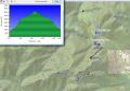
Hiking Buck Mt (the Towers, 3700 ft elev) (Fri, 10-12-2012) --- 9.2 miles with 3000 ft elev.
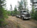
Les and I were planning to scramble hike Charlia Lake via Marmot Pass, but the weather forecast was lousy with high chance of raining. We were expecting to get wet and decided to hike the Elbo Creek near the Mt Walker (NE Olympics) that would give us some distance with elevation gain. Time spent were 0830-1225. My GPS indicated 9.2 miles which seemed to be more reasonable. For some reason, it was 10 miles last time. After all, it did not rain and even had some sunshine briefly.
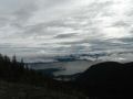
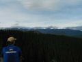
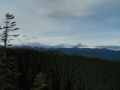
I did not have the views during previous hike to the area but, this time, we had a view to the Olympics (Mt Constance, Buckhorn Mt, Mt Townsend) past the Towers, and the Brothers Mt at the highest point of the logging road.
|
|
|
|
|
|
|
|
|
|
|
|
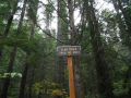
Trailhead
Direction:
a.
The trailhead (790 ft elev) is across Hwy. 101 from the Mt.Walker access road,
and a few hundred feet south. It
is marked as Rocky Brook Road.
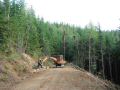
b. Drive
up Rocky Brook Road less than a quarter mile and look for a wide spot on the
right, and the trailhead (not well marked) on the left side.