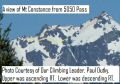
Climbing Mt Constance (7743ft, About 19.6 miles with 7800 ft elev gain), 7-8 Sept 2013
Mt Constance is one of three prominent peaks (The Brothers MT (6866 ft), Mt Jupiter (5701 ft), and Mt Constance (7743 ft)) that can be seen across the Puget Sound. Now, I climbed them all !!! It is the 3nd tallest mountain in the Olympics (Mt Olympus (7980 ft), Mt Deception (7788 ft), and Mt Constance (7743 ft)). It appears as the tallest from the Puget Sound as the other 2 mountains are located deeper in the Olympics. It's also probably the toughest non-technical climb (no roping) with only scrambling with a helmet, ice ax, and gloves. It's non-technical routes, "Finger Rraverse" and "Terrible Traverse" are the well known phrases to the Olympics climbers. Climbing up the North Chute, close to 7435 ft elev, "Finger Traverse" involves crossing a ledge above a cliff with the fingers jammed into the crack. Then, coming down on the South Chute, one traverses the "Terrible Traverse" at 7435ft elev crossing above a huge cliff. Our routes were just that: ascended via the North Chute with the Finger Traverse and descended via the South Chute with the Terrible Traverse.
Mt Constance was on my mountain climbing list and has asked the former PWC president, Paul Dutky who had climbed the Mt three times to take me to the Mt Constance summit. Since I got to know him since 2011 as I started enjoying outdoor activities in 2010, he has been one of my favorite people to hike, backpack, mountain bike, kayak, snowshoe, and XC ski. In early August this year, I was not sure if it was for me but, surprisingly, Paul wanted to sponsor the trip in early September. Its schedule worked out perfectly for me. I wanted to help him coordinate the trip, so, I volunteered to be the trip coordinator who made reservations to the Lake Constance permits from the National Park Service and worked out the logistics. Lake Constance is one of the places where require permits before spending overnight in the Olympics National Park. We had 6 permits for 2 nights but had only 5 climbers recruited from PWC, Kitsap Hikers Facebook, and their friends. Our original climbing schedule was for Fri-Sun, 6-8 Sept, but we shifted one day to the right, Sat-Mon, 7-9 Sept because it was close 80% chance of rain on Fri and was getting better on Sat. We got really lucky with the weather. It did not rain on Sat (low 50 - high 60s), 7 Sept and was all blue sky (a fantastic day) on Sunday (low 40s - 70s in the mountain). In fact, on Sunday, it reached 80s in town that made the summer weather return. We could not ask for a better weather.
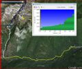
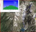
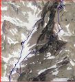
Routes in Google Earth and in a picture:
|
|
|
|
|
|
|
|
|
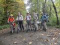
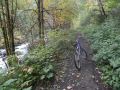
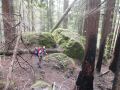
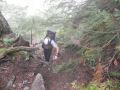
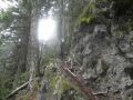
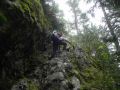
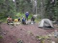
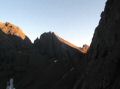
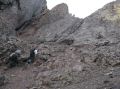
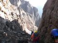
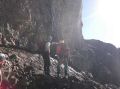
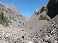
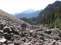
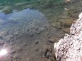
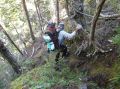
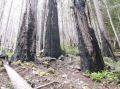
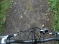
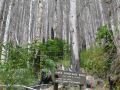
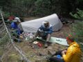
Day 1: We biked to the Lake Constance trailhead and backpacked to the Lake. 3.8 miles of bike (w/700 ft elev gain, 1045-1200) and 3 miles (w/3400 ft elev gain) of backpacking to Lake Constance (1220-1530). A portion of the Dosewallips Road (about 16 miles in from Hwy 101) was washed out in 2002 and has not been restored, which makes about 3.5-4 miles of walk or bike to the Lake Constance Trailhead. The end of the Road is the Dosewallips Ranger Station (about 7 miles in) where I biked & hiked once back in 2011. Greg and Rahul carpooled with Paul, and Brian and I carpooled. We took our bikes and left them at the bridge just below the Lake Constance trailhead. At the Lake Constance trailhead, its sign says it all: 2 miles 3400 ft elev gain (my GPS indicated about 3 miles though). No doubt that it is the steepest maintained trail in the Olympics. Putvin trail is also steep but, I say that, it's 3-4 times toughter trails with its length and scrambling (rugged trail with tree roots and rocks). Right off the trailhead, it was steep. Some of the readings said that its class 3 bacpacking up the Lake Constance Trail. I agreed with its assessment. Several places were quite exposed or required extra attention.
My GPS lost its signal more than half of the time looking at its recorded data. To make up the lost GPS signal for the trail, I estiamted tracks for the Dosey Road and the Lake Constance Trail. We took about 10 min break near the Constance Creek, mainly washing off with cold water. Surprisingly, we reached the Lake just over 3 hors at 1530 ! I was the slowest. I had lots of energy but did not want to over exert myself for the next day climb. I kept at my own steady pace where my legs did not feel pain.
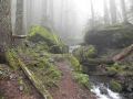
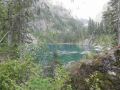
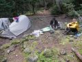
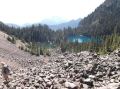
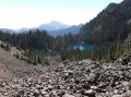
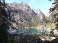
We continued to go around the Lake easterly to our camp sites on the North of the Lake. There was 5 camp sites with one "Throne". We took 3 of them and another group with 4 parties took the #5 camp site. We had a nice hot meal, watched the sunset alpantal of the mountain, and watched the sky filled with the stars which were an excellent sign for the nice weather next day. We turned in early at 2030. Reveille was at 0400 and expected to start climbing at 0500.
|
|
|
|
|
|
|
|
|
|
|
|
|
|
|
|
|
|
|
|
|
|
|
|
|
|
|
Day 2: Summited
Mt Constance. 6 miles of roundtrip with
3700 ft ekev gain from Lake Constance (0515-1030 to summit, 1100-1130
to the Lake). Hiked out (6.6 miles)
to Dosey TH (1320-1830)
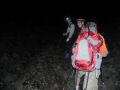
We got up at 0400, had some coffee, had some left over
meal, used the "Throne", and
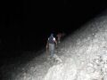
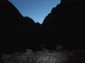
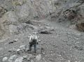
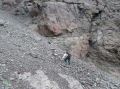
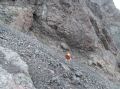
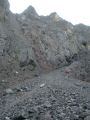
headed over the Talus and to the Avalanche Canyon at 0515. It was pitch dark, so, everybody used head lamps till
0630 or so. We headed straight north
in the canyon between Mt Constance and Inner Constance for the North Chute. Paul, our climbing leader, had the routes in
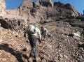
his head and did not even need a map for our trip. The
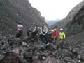
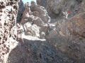
canyon was basically filled with boulders which require
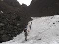
careful footing. A small patch of snow
was no problem to cross. We saw the cat's ears
(one of the benchmarks climbing Mt Constance) in the
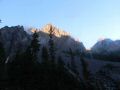
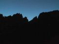
dark. As the Sun started to rise at
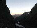
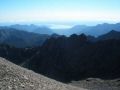
0638, looking back South toward the
Lake, the impressive Brothers MT was right in the middle of the
canyon on the South view,. Then, looks
like it was the last chute, we went up
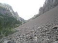
this very steep scree slope that had reasonable foot holding
but had constant shouting of " Rock" for the climbers below. Abut 3/4 way up, a
valley ball sized rock was loose from above me, When I
rerouted rock away from me and two
climbers below me (Rahul and Greg). it jammed my finger. It was
not hurting until I got home !!! It was
badly bruised after all. At some point
getting over the avalanche canyon, I did some rock climbed to prevent rock falling below
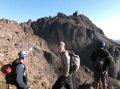
me. After crawling to the top of the North Chute which
narrowed and flattened out a little, we
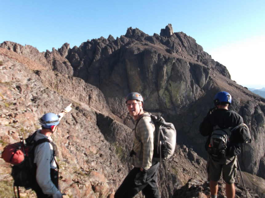
were able to see the summit block for the first time to the North.
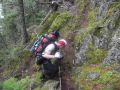
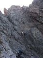
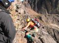
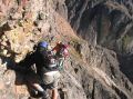
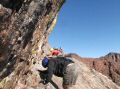
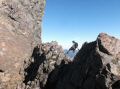
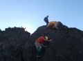
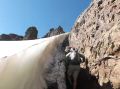
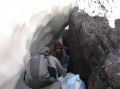
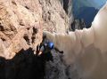
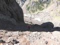
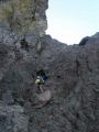
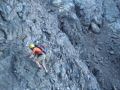
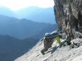
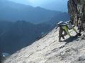
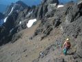
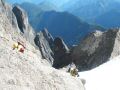
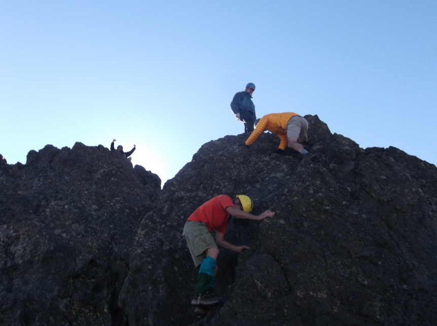
We took a break before the infamous "Finger Traverse" which
was hidden around the corner. Getting
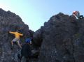
to the Finger Traverse was not simple but required continuous
scrambling. On the Finger Traverse,
Paul was already crossed and taking pictures of us. On
the traverse, the first two steps were excellent as there
were foot holdings and good hand grips.
Then, last 2-3 steps about 4-5 feet,
I did not have foot holdings. It was there but my foot was about 1-2 inches
shorter. Later on, I found out that I
was too tense and in curled position that prevented reaching below with my feet. I had to ensure both of my hands had good
holdings with equally distributed strength so that if one of holdings was bad then I still
have the other arm to support me.
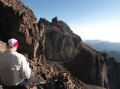
Slowly, it was done safely. Near
the end when I was safe, I looked
down to check out the cliff (1000-1500 ft cliff) while in rest position. Those 4-5 feet traverse were the only one
place in the Olympics that I knowingly risked my life
with only my two arms support. I
thought to myself that if I had done some rock climbing with my arms,
I would feel more comfortable.
Intense concentration and survival mode made the trip safely without
panicking.
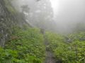
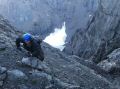
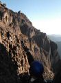
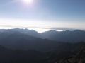
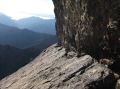
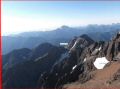
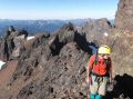
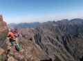
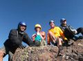
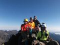
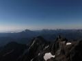
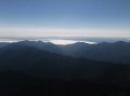
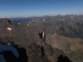
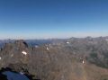
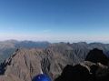
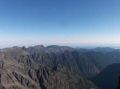
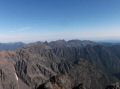
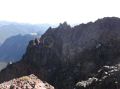
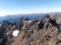
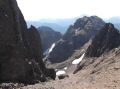
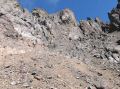
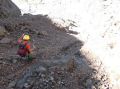
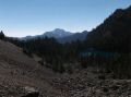
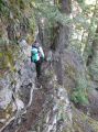
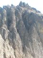
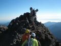
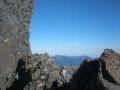
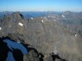
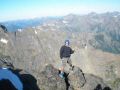
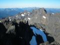
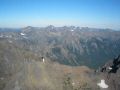
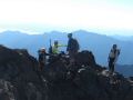
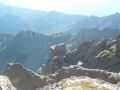
This was the 2nd time that had significant exposure in climbing since 2011. The first was at the last 100 ft ascent of the Mt Hood summit. A fall at those places would be fatal. One place that I really got spooked during scrambling was when I was scrambling to the base of Mt Walkinsow a couple of months ago. It was not particularly difficult but needed more careful due to loose rocks or grips. I hastely transferred my weight to my left arm not properly checking its holding the side of a pillar. The rotten rock was brittle and got broken. Just before loosing my balance, my right arm was wrapped around the pillar, but I was frightened and realized my mistake. I needed to tell myself that "always check the hand and foot holdings before transferring weight. And always balance the weight in 3 points (2 arms and 1 leg or 2 legs and 1 arm)."" After the Finger Rraverse around 7435 ft elev, there were still significant amount of scrambling over sharp and loose rocks, and narrow ledges with significant exposures to get to the summit but all of them were trivial as I had good both footings and holdings. For the summit block, I thought that the peak had a few spots but there were more than enough room for 5 of us. If it was windy, it's probably true that 2-3 spots at the peak are the good number. We took some time l enjoying ourselves looking at the unobstructed 360 views of the Olympics. We took a lunch break below the summit block looking at North: Gray Wolf Ridge, Iron Mt, Mt Worthington, Mt Townsend, etc.
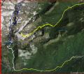
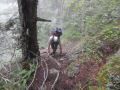
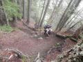
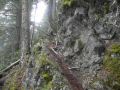
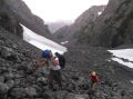
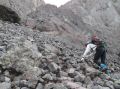
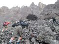
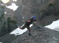
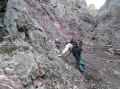
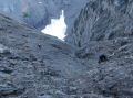
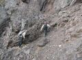
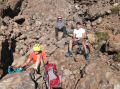
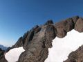
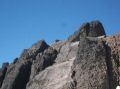
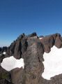
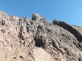
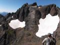
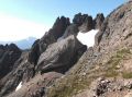
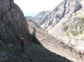
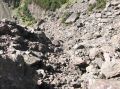
From Lake to before
the Finger Traverse:
|
|
|
|
|
|
|
|
|
|
|
|
|
|
|
|
|
|
|
|
|
|
|
|
|
|
|
|
|
|
|
|
|
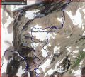
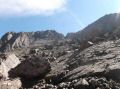
From just before the Finger Traverse to the Summit:
|
|
|
|
|
|
|
|
|
|
|
|
|
|
|
|
|
|
|
|
|
|
|
|
|
|
|
|
|
|
|
|
|
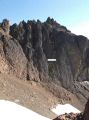
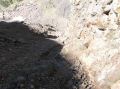
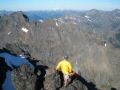
Our descent route was different. We took the terrible traverse and to the South Chute. Terrible traverse was not as much terrible as I anticipated, maybe because the snow on the ledge melted away, and the most of climbers could go around the steep snow slope after the ledge. It was a decent ledge that we could just walk across. If it was filled with snow, it would have been terrifying and extremely dangerous as almost vertical cliff was looming below. Then, we had some very steep snow slope to cross (I guess it was part of the Terrible Traverse as we were still traversing to the place where both the Norht and South Chute started. We opted to navigate around the steep snow slope. All of us ended up rock climbing. In retrospect, after seeing the terrain and our route to the South Chute, we could go lower losing about 150-200 ft elev and came back on the other side. The South Chute was also steep but had very loose scree. I basically ran down the steep scree chute along with a bunch of screes. We also observed the Cunningham Pass. If one comes over the Cunningham Pass via the Tunnel Creek Trail (to 5050 Pass), one can rejoin the South Chute to climb the Mt Constance. I think coming through the Cunningham Pass would be easier and fun routes with full packs. But need to ensure that there is no snow on the Terrible Traverse, or need to seek a different route. One couple stayed overnight or 2nd night just north of the Cunningham Pass (that we observed a yellow tent on a slope) and scrambled up to the summit from the North bypassing those infamous traverses !!! One of Kitsap Hikers and Kitsap Mountaineers mentioned that they bypassed the Finger Traverse to the west. So, there are many different scrambling routes other than the "Finger Traverse" and the "Terrible Traverse." However, I felt that one needs to experience those infamous traverses for the Mt Constance Scramble Climb.
When we reached the Avalanche Canyon and doing rock hopping toward the Lake (still needed full attention with careful footing), I was so happy that all of us were safe. It was just an incredible experience and much thanks to Paul Dutky for taking us. Close to the Lake Constance, the glaciated lake looked more beautiful from the North with the Brothers Mt in the background. Amazingly, we got back to our campsite at 1320. The total hours of climbing was 8 hours (4.5 hours to the summit, 1/2 break, and 3 hours back to camp site). Some of us dip in the lake to cool down and relaxed till 1500. We left the camp site 1500-1520, and got back to the Lake Constance Trailhead at 1800. Then, it was a blast riding the down hill with a bike. I was glad that we opted to bring our bikes. We opted to hike out but would have been much better if we stayed one more night at the Lake Constance. I felt great but the others were close to their physical limit as one of them fell on the trail and the other person cancelled my scheduled Bailey Range Traverse.
Summit to Lake Constance TH.
|
|
|
|
|
|
|
|
|
|
|
|
|
|
|
|
|
|
|
|
|
|
|
|
|
|
|
|
|
|
|
|
|
In overall, it was indeed a different level of scrambling and required a high tolerance in height fear and with good physical condition. The whole climb, in general, involved careful footing, limited rock climbing (careful with loose rocks), and lots of scrambling. I thoroughly enjoyed the trip. I felt that most of the climbing mountain trips like Mt Adams, Mt St Helens, Glascier Peak, etc are not as much enthusiastic for the 2nd climb, but Mt Constance and Mt Rainier that I climbed this year, I want to go back again.
Pictures from Rahul:
|
|
|
|
|
|
|
|
|
|
|
|
|
|
|
|
|
|
|
|
|
|
|
|
|
|
|
|
|
|
|
|
|